
One of my earliest and most convincing introductions to the POLE SHIFT theory was a book by Rand Flem-Ath titled: When the Sky Fell: In Search of Atlantis
His premise was that pole shifts have devastated the Earth many times, wiping out civilizations like the last one (Atlantis) which was probably centered on Western Antarctica – which was warm and temperate, at a latitude like England today – prior to the last POLE SHIFT.
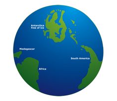
One of the many bits of evidence in favor of this idea is the ancient Egyptian map which the priests said depicted the ancient homeland of Atlantis.

Above: Athanasius Kircher’s map of Atlantis, placing it in the middle of the Atlantic Ocean, from Mundus Subterraneus 1669, published in Amsterdam. The map is oriented with south at the top, as the Egyptians chose to do on maps – as South pointed both to the island homeland of the primeval ones and to the source of the Nile. The markings of what the land masses represent are Kircher’s assumptions – placing Atlantis in the North Atlantic. But what if the lands on the left/west are not Africa and Spain, but Madagascar and Africa?
Plato gave many details about Atlantis and Flem-Ath suggests the information fits Antarctica.
“Although this is a 22 year old presentation it was groundbreaking in its time. Very interesting arguments and convincing. Flem-Ath uses the theory of “Crustal Displacement” to explain a host of unanswered questions.”
I think the evidence suggests that catastrophic pole shifts occur in a periodic cycle equal to half of the cosmic Great Year of the Precession of the Equinoxes – roughly every 12,960 years – and that we are due for the next event in the early 21st century.

[youtube https://www.youtube.com/watch?v=jVsFxo05y70&w=865&h=487]